PROTOTYPE WIRELESS WAYFINDING SYSTEM FOR TRAINING AND JOB COACHING SUPPORT FOR WORKERS WITH COGNITIVE IMPAIRMENTS
Vimlesh Shukla, Arpit Mittal, Prem Kumar Sivakumar, Robert F. Erlandson
Wayne State University, Detroit, MI 48202INTRODUCTION
Indoor way finding is a problem for many individuals with cognitive impairments. The prototype system is implemented using a wireless sensor network (WSN) that used ten reference nodes, one coordinator node, and a blind node. The embedded system controls the network and the software algorithm estimates the blind node to within 1 meter. The system has been tested on janitorial carts in an office wing of the Jewish Vocational Services (JVS), Southfield, Michigan. The blind node was attached to a janitorial cart. The cart’s location was overlaid on a drawing of the office wing’s floor plan displayed using the control computer’s monitor. JVS is a NISH affiliated agency that provides vocational training for workers with cognitive impairments. The prototype system is the first step toward a system that will enable JVS to effectively train its clients and improve on-site worker efficiencies by allowing a supervisor to monitor his/her own team and provide individualized task prompting to workers.
BACKGROUND
JVS is a CARF certified, NISH affiliated, non-profit organization that offers programs and services throughout Metropolitan Detroit. JVS supports individuals, challenged with disabilities, in the workplace and provides on-site, supervision and coaching at community-based employers through their janitorial operations. Job Coaches have expressed interest in finding a way to remotely monitor their employees and provide task prompting.
Technologies such as Bluetooth, RFID, and Infrared provide solutions for indoor wireless networks. However, most of these technologies are susceptible to noise or have range limitations [1]. This project utilizes the IEEE 802.15.4 and ZigBee standard to provide a low-cost and easily implemented solution for developing a wireless network. Smart Buildings that use ZigBee ready nodes for lighting and environmental control are rapidly increasing [2]. Therefore, emerging building infrastructures can support a ZigBee network for wayfinding. The ZigBee protocol uses the received signal strength indication (RSSI) and link quality indicator (LQI) to correlate signal strength to location [3].
The Enabling Technologies Laboratory (ETL) at Wayne State University has a long-range goal of developing an indoor wayfinding and localization system that can support the employment of individuals with cognitive impairments. This system has two distinct customers: 1) the service providers (Job Coaches and trainers) and 2) the workers with cognitive impairments. The service providers need to monitor, supervise, and train their clients. The clients need assistance in navigating their environment and focusing and remembering assigned tasks.
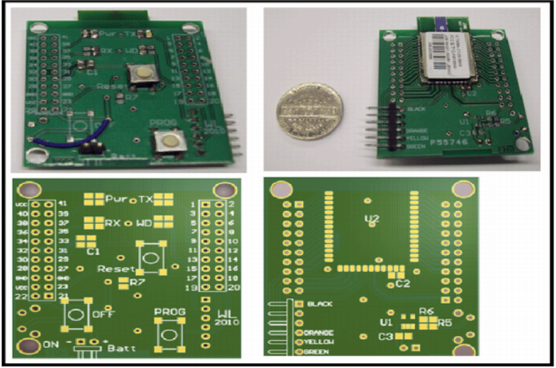 Figure 1: Photo of the prototyped Jennic device both in a 3D model from Altium Designer and actual fabrication. d
The design strategy was to first prototype a single node platform using the Jennic Microcontroller, and then perform testing to determine a distance to LQI model. Using this model, the task was to implement a network suitable for an office building, and then develop an algorithm for localization. Finally, a set of testing procedures for measuring system performance was established. One of our goals for the WSN implementation was to provide a portable solution, requiring minimal effort to setup. By selecting the Jennic 5139 Wireless Microcontroller, we minimized design size by taking advantage of the integrated RISC microcontroller and IEEE 802.15.4 transceiver. Figure 1 shows a photo of the prototyped Jennic device both in a 3D model and actual fabrication. Poor localization results from initial tests suggested that the blind node design include an accelerometer to improve the localization algorithm. This conclusion has been reached by other groups as well [5].
LQI Determination
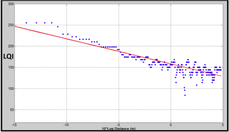 Figure 2a: Log-linear relationship between distance and LQI. Best-fit line determined from raw data set. d
A crucial step was to determine reference node placement. Since our current Jennic model contained a directional antenna, distance calibration was performed using line-of-sight positioning with two nodes, one transmitter and one receiver. Starting from the receiver location, the transmitter traversed a linear path moving away from the receiver node.
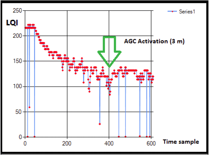 Figure 2b: Jennic AGC activation shown in the LQI reading after 3 meters. d
The observed LQI measurements were inversely proportional to distance moved. Studies from [5, 6] expressed the log-linear model used to quantify this relationship and how to empirically determine 𝐴, the received power and 𝛾 the loss parameter. Ten tests were conducted and the average 𝐴 𝑎𝑛𝑑 𝛾 were -15.67 and 214.58 respectively. The automatic gain control (AGC) on the Jennic activates beyond 3 meters producing unreliable LQI readings. This indicates that reference nodes should be placed no more than 3 meters apart. This constraint is acceptable for office spaces and the newer Smart Buildings that have high densities of ZigBee modules in the infrastructure. Figure 2a shows data generated from the line-of-sight tests and Figure2b shows the LQI measurements beyond 3 meters.
Network Topology
 Figure 3: Illustrates the star network topology with the blind node, reference node, and coordinator. d
A star network infrastructure is used because of its network robustness. If one reference node is removed from the network, the others are not affected. Figure 3 illustrates the basic network topology. The localization of a blind node is estimated from the LQI measured from each reference-blind node pair.
From the network topology, three different firmware applications were developed for the Jennic Wireless Microcontroller modules so as to function as a coordinator node, reference node, and blind node. The blind node broadcasts its acceleration signal to all nodes listening to its address. The reference nodes continually receive data from the blind node until there is a request from the coordinator. The coordinator sends requests to each reference node to retrieve the accelerometer and the link quality data. The software algorithm performs the localization when it obtains the coordinator data.
Localization Algorithm
The localization algorithm has evolved from methods using signal strength measurements, to a more robust triangulation method. The key in localizing the blind node is to select the suitable set of reference nodes forming a triangle. Filtering the LQI from the past data reduces the environmental noise. The blind node’s onboard accelerometer provides information about its movement and trajectory direction. The algorithm executes in real- time on a MATLAB platform.
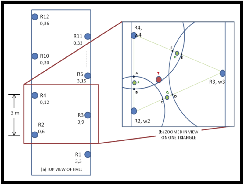 Figure 4: a) The reference node placement in a zigzag pattern spaced 3 meters apart. b) A zoomed in view of a set of reference nodes. d
Figure 4a shows the top view of the hall where the reference nodes are placed in a triangular pattern such that such that at any given point three reference nodes are in close proximity (3 meters) to the blind node. Figure4b shows close view of three reference nodes forming a triangle.
We used the log-linear model established by the data of Figure 2a to estimate the distance from each of the reference nodes to the blind node. Acceleration data from the blind node determined its movement pattern; when stationary the LQI was unreliable due to the Jennic’s AGC. From the weighted centroid algorithm [7, 8], weights are assigned to each reference node based upon its calculated blind node distance. The circles in Figure 4b display the estimated uncertainty in localization from each node. Larger circles correspond to higher uncertainty and lower LQI measurements, and conversely for the smaller circle. The final step estimates the location from the new weighted points. This method is a variant of the adaptive weighted centroid algorithm [8].
Figure 5 shows the network layout with X and Y coordinates and node positions on the Engineering Building floor plan.
RESULTS
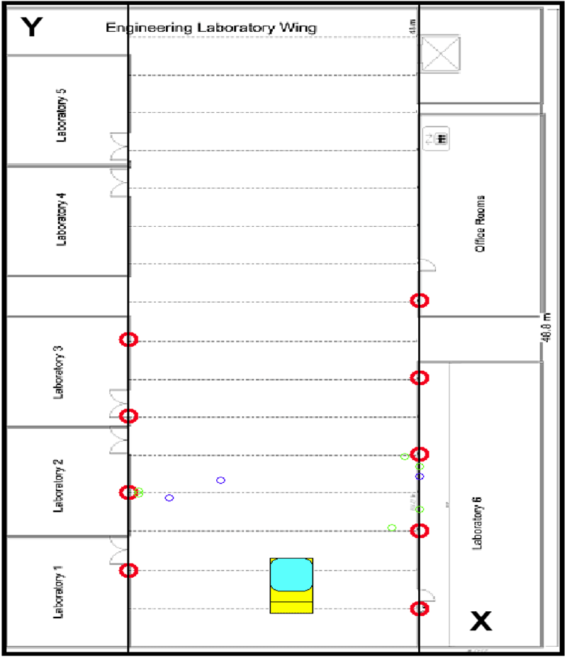 Figure 5: Blind node localization on the Engineering Building floor plan. d
During development, 46 tests were conducted in the Engineering Building hallways. The data presented here are from field-tests conducted at the JVS facility down an office hallway length of 30 meters and width of 1.5 meters. The blind node was mounted on a janitorial cart at a height of 1 meter and 10 reference nodes were positioned. Three trials were performed where the user would traverse the hallway with the cart passing each reference node. To measure position accuracy, locations estimated from the algorithm were compared to predefined points on the map. Table 1 shows the actual and estimated locations from the algorithm.The average estimated location was taken from the three trials at the JVS facility during the testing. Similar results were seen from 46 trials performed in the Engineering Building.
| PredefinedLocation(meters) | Average Estimated Location(meters) | Absolute Difference (meters) | %Error | ||||
|---|---|---|---|---|---|---|---|
| X | Y | X | Y | X | Y | X | Y |
| 0.75 | 4 | 0.83 | 3.62 | 0.08 | 0.38 | 11% | 10% |
| 0.75 | 7 | 0.11 | 6.81 | 0.64 | 0.19 | 85% | 3% |
| 0.25 | 13 | 0.10 | 12.22 | 0.15 | 0.78 | 60% | 6% |
| 1.25 | 16 | 1.42 | 15.75 | 0.17 | 0.25 | 14% | 2% |
| Average | 0.26 | 0.40 | 42% | 5% | |||
| std | 0.25 | 0.27 | 36% | 4% | |||
From the table, the average X and Y coordinate estimations were within 1 meter of the predefined locations. On average, the percent error for the X coordinate was much higher than the Y coordinate; however, the absolute difference was lower for the X coordinate. This is because the user motion was mostly restricted in the X direction. The Y coordinate in most situations will vary greatly because the user will be traversing down the hall in the Y direction; therefore, this parameter determines the accuracy of the localization. As shown in the table, the average estimated percent error for the Y coordinate is 5%, and the difference measurement was 0.4 meter, less than 1 meter.
CONCLUSION
The wayfinding system has been successfully demonstrated at the JVS facility. The system met our objectives for providing a solution that is low-cost, portable, easy to use, and is robust. From the test results, we have been able to localize a janitorial cart to within 1 meter accuracy. The network can be setup in most office hallways with 3 meter spaced node placement.
An issue with the current design is that using a directional antenna requires the nodes to be placed at the same height for line-of-sight positioning. In addition, the Jennic’s AGC limits the range to 3 meters for reliable data. In the future design, the blind node will use an omnidirectional antenna with higher gain instead of the directional antenna. This modification will alleviate the height-positioning problem and improve the range of the transceiver. Additional plans are to convert the existing MATLAB interface to a web application allowing the Job Coaches access to the interface on their smart phone or computer.
JVS’s response has been very positive toward the system and has expressed great interests in the improvements in the software. Our direct representative from JVS, Derek Finely, stated, “This service is a great application for indoor wayfinding by providing our Job Coaches the flexibility in being able to remotely monitor the location of our workers in most facilities”.
REFERENCES
- A. L. Liu, H. Hile, H. Kautz, G. Borriello, P. A. Brown, M. Harniss, and K. Johnson, "Indoor wayfinding:: developing a functional interface for individuals with cognitive impairments," presented at the Proceedings of the 8th international ACM SIGACCESS conference on Computers and accessibility, Portland, Oregon, USA, 2006.
- G. Wenqi, W. M. Healy, and Z. Mengchu, "ZigBee-wireless mesh networks for building automation and control," in Networking, Sensing and Control (ICNSC), 2010 International Conference on, 2010, pp. 731-736.
- M. Sugano, T. Kawazoe, Y. Ohta, and M. Murata, "Indoor localization system using rssi measurement of wireless sensor network based on zigbee standard," From Proceeding (538) Wireless Sensor Networks, vol. 7, pp. 54–69, 2006.
- A. K. Chandra-Sekaran, P . Dheenathayalan, P. Weisser, C. Kunze, and W. Stork, "Empirical Analysis and Ranging Using Environment and Mobility Adaptive RSSI Filter for Patient Localization during Disaster Management," in Networking and Services, 2009. ICNS '09. Fifth International Conference on, 2009, pp. 276-281.
- M. Barralet, H. Xu, and D. Sharma, "Effects of antenna polarization on RSSI based location identification," in Advanced Communication Technology, 2009.ICACT 2009.11th International Conference on, 2009, pp. 260-265.
- H. Xu, "Antenna Polarization as Complementarities on RSSI Based Location Identification," in Wireless Pervasive Computing, 2009. ISWPC 2009.4th International Symposium on, 2009, pp. 1-5.
- J. Blumenthal, R. Grossmann, F. Golatowski, and D. Timmermann, "Weighted centroid localization in zigbee- based sensor networks," Intelligent Signal Processing, pp. 1–6, 2007.
- R. Grossmann, J. Blumenthal, F. Golatowski, D. Timmermann, and R. Str, "Localization in Zigbee-based Sensor Networks," 2007.
Special Thanks to Derek Finely (JVS) and Santhosh Kodimyala (ETL). Funding for this project came from several sources; an NSF student design grant RAPD#0752709, Enabling Technologies Laboratory research funds, and private foundations.