Edward Steinfeld1,2
1University at Buffalo, 2Idea Center (Buffalo)
INTRODUCTION
Well-being and feelings of self-worth among people with early-stage dementia are affected by independent outdoor activities. [1] Being able to navigate the outdoor environment contributes significantly to independent living and quality of life for people with cognitive difficulties and neurodegenerative diseases. This paper presents the research for the design of a way-finding tool (smartphone app) for people living with mild to moderate dementia and cognitive difficulties that affect visual-spatial skills and a sense of orientation.
The process to determine a route between an origin and destination is defined as way-finding. [2] Way-finding can be decomposed into three actions: 1) orientation at the point of origin, 2) navigation between origin and destination, and 3) destination confirmation. Usability of a way-finding tool can be defined based on its performance in the context of all three components. Customizable and adaptive interface, collaborative or single user interaction, “survey” or “egocentric” mode for map presentation and interface complexity are the major decision points for determining the usability, learning curve and user experience of the tool. Based on the literature review, the study of current applications and an interview with a potential user, this paper identifies and discusses important aspects of the tool design. The discussion offers a scope for further research and literature review in order to define design guidelines for the tool.
RESEARCH INTENTIONS
METHOD
Literature Review
Gary Evans, in his paper on environmental learning and cognitive mapping, demonstrated that, in the process of environmental learning, landmarks are memorized early, functioning as anchors for paths to be filled in between them. [5] Additional literature reviewed included research papers and online resources to understand challenges faced by people who live with cognitive difficulties and their concerns in way-finding as well as general interactions with indoor and outdoor environments. [6-9] The literature review found that less research has been conducted on outdoor navigation compared to indoor navigation for people with neurodegenerative diseases and TBI.
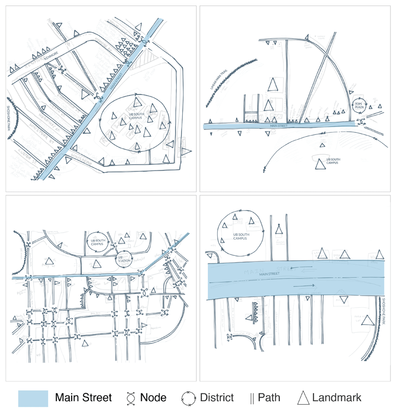
To explore the usefulness of hand drawn mental maps some friends and acquaintances were asked to draw their neighborhoods. For analysis, these maps were simplified using the elements of legibility defined by Lynch. Figure 1 presents four such maps and it can be observed that, almost all the participants used the main street as an anchor to place landmarks and other streets. Also, the number of landmarks and the complexity of the map varied for each participant based on factors like places they had visited, their interests, route they took and mode of transport they used.
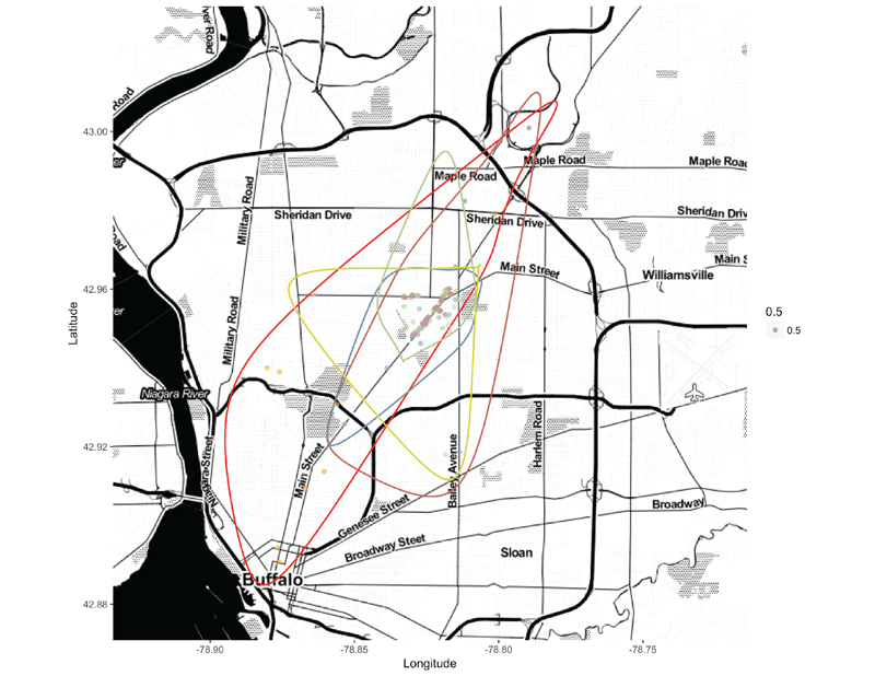
A visualization of the home-range for 6 participants was made by plotting the landmarks from their mental maps. See Figure 2. It was observed that the boundaries of home-range differed significantly based on whether they had access to automobiles, used public transportation or only university transportation.
Semantics of landmarks on the drawn maps also varied based on their interaction with the place and its importance for them. This exercise also uncovered the challenges in terms of time and effort that were required to draw a mental map and the reticence participants had in the act of drawing. People with disabilities may have even more difficulties drawing such maps and thus, other ways to understand their mental maps will be needed to understand their knowledge of an environment.
Current Applications
Case studies of projects and available tools were studied to gather insights on possible design solutions, design opportunities, and challenges. Bikearound pairs a stationary bike with Google Street View projected on a screen to take patients on a virtual ride around a place they have previously visited and is important to them. It was developed to encourage older people with dementia to exercise more in a safe way. [10] The JAM (Just a Minute) card app is a digital innovation developed by the NOW Group which is supporting people with learning difficulties and autism. It began as a plastic credit card sized card with one side of the card saying ‘Just a minute’ and other side saying ’Please be patient, I have a learning disability/difficulty’. The card was originally developed for those with learning disabilities but also proved useful for anyone with a communication barrier. [11]
Walk [Your City] is a project that complements traditional approaches to way-finding by providing an interface to link informational street signs for people with web-based campaign management and data collection. [12] ClickAndGo Navigation is a project that uses ibeacon technology to develop a navigation system for people with visual impairments. [13] Glympse and Trail are mobile apps for location sharing and creating custom trails on a map. [14,15] These apps demonstrate the feasibility, constraints and opportunities for constructing maps with custom semantics and content as a potential design direction.
Interaction with potential user
An interview with an individual with a TBI revealed some of the concerns, fear, and challenges this group faces in way-finding tasks. TBI has impacted his social life and limited his interaction with the surroundings. He shared his experiences and concerns about adaptive devices he currently has and those he would like to have. He was reluctant to use devices requiring haptic interaction due to mild dyslexia he experienced in stressful situations. He noted that the ability to slow down the pace of audio information and easily implement repetition of information were crucial factors for him. He shared his fear of losing control, getting lost, panicking and not being able to ask strangers for directions. Way-finding apps like google app present information in an overly complex way and they are difficult to use for orientation. Having a home in the countryside, he mentioned a major stress point for him was navigating the regions of low connectivity where the GPS would not work.
The design for the new tool will use a co-design strategy. Thus, this brief session of brainstorming for features with a potential user shed light on the how music and sound might improve memory by making associations with a place or navigating to a place. Other potential design strategies identified were the provision of a simplified interface that can assist the user in sharing locations in order to feel secure, and the generation of meaningful instructions when connectivity is poor.
DISCUSSION
Based on the literature study, exploratory study and user interaction several design decision points and features were identified that are crucial for designing a tool that aims to simplify the way-finding process for people with cognitive and learning difficulties.
Cognitive difficulties present a wide spectrum of challenges. Neurodegenerative diseases are often coupled with other challenges that occur related to aging. The degree of difficulty in way-finding experience is further influenced by factors like the stage of a disease, previous experience, social interaction style and lifestyle. Designing a tool for an audience with varied experiences, abilities, and concerns cannot follow a ‘one size fits all’ approach to design. Rather, it calls for designing a system or a tool that adapts itself to the needs and expectations of each user. A design process that follows a co-design approach will help to understand the range of user perspectives, preferences and priorities. But, constructing a tool that learns from the user is also essential. A two-step process of “learning from the user” could include conscious user input to build a customized interface at the start followed by an adaptive AI algorithm deriving optimized parameters from user generated data causing a feed back loop.
Caregivers and significant others play an important role in the daily interactions of a person living with cognitive challenges. The role of the caregiver and significant other expands as a degenerative disease progresses. Our design will be focused on early stages of the disease when outdoor navigation is important and encouraged and on those who are living independently. To maximize its potential, it is important to design a tool that supports both collaborative interactions with the tool, i.e. both the individual with a disability and their caregiver or significant other, including the flexibility of switching between the two modes as the need arises.
Lack of attention, losing a track of destination and wandering are few of the many concerns in dementia. Similarly, TBI and other cognitive challenges are associated with a loss of orientation. Given these concerns, the tool should include features like tracking user-location during navigation and generating alarms when there is deviation from a predefined route. It is also important to understand the implications a tool might have for user’s emotions and self-esteem. It is important to offer a balance between a sense of security that comes by knowing that someone can be approached when needed and a sense of freedom by not being tracked or making decisions and exploring new routes. Keeping the user in control of making decisions within boundaries defined by ability will assure safety. Setting the boundaries through a collaboration between the user, their caregiver and their loved ones should also be an important aspect of the tool. An example might be the establishment of a geo-fence, a geographic boundary within which an individual can navigate without tracking or generating alarms.
There are two types of maps that can be utilized for way-finding. Survey maps present a bird’s eye view of the overall route and thus provides a holistic image of the route while an “egocentric” map provides easy to understand set of instructions based on the location of the user. For some, survey maps could be more beneficial because they help to create an overall mental map of a place, while others might prefer a simple instruction based approach without the potential to explore other possible routes. Thus spatial representation becomes an important decision point while designing the user experience. Offering a feature that allows the user to easily select and switch the presentation mode could be very beneficial in customization.
The research identified several important features that will tend to make a tool complex. Designing an interface that offers these features in a way that is comprehensible, demands less cognitive effort and involves a low learning curve is crucial for insuring the usability of the tool. The interface should focus on one instruction at a time and involve no more than a limited number of interaction points per session. The number of interaction points has to be determined from available research or a user study with a sample user set that represents the target audience. Likewise, further research is needed to identify challenges, concerns, and opportunities offered by visual, audio and haptic modes of interaction.REFERENCES
- Olsson, A., Lampic, C., Skovdahl, K., Engström, M., Akademin för hälsa och, a., Avdelningen för hälso- och, v., & Högskolan i, G. (2013). Persons with early-stage dementia reflect on being outdoors: A repeated interview study. Aging and Mental Health, 17(7), 793-800. doi:10.1080/13607863.2013.801065
- Golledge, R. G. (Ed.). (1999). Wayfinding behavior: Cognitive mapping and other spatial processes. JHU press.
- Milgram, S. (1977). The individual in a social world: essays and experiments. Reading, MA: Addison-Wesley Pub. Co.
- Lynch, K. (1960). The image of the city. Cambridge: MIT press.
- Evans, G. W., Brennan, P. L., Skorpanich, M. A., & Held, D. (1984). Cognitive mapping and elderly adults: Verbal and location memory for urban landmarks. Journal of Gerontology, 39(4), 452-457
- A Walk Through Dementia. (n.d.). Retrieved November 15, 2017, from http://www.awalkthroughdementia.org/
- Movement, M. (n.d.). Molly and Joey - A Mother and Son's Journey with Dementia. Retrieved November 15, 2017, from https://mollysmovement.com/
- Rainville, C., Passini, R., & Marchand, N.(2001). A multiple case study of wayfinding in dementia of the Alzheimer type: Decision making. Aging, Neuropsychology, and Cognition, 8(1), 54-71. doi:10.1076/anec.8.1.54.846
- Liu, A. L. (2010). Design of an adaptive wayfinding system for individuals with cognitive impairments. (Dissertation/Thesis), ProQuest Dissertations Publishing, Retrieved from http://buffalo.summon.serialssolutions.com/2.0.0/link/0/
- BikeAround. (n.d.). Retrieved January 12, 2018, from http://www.camanio.com/us/products/bikearound/
- Supporting people with learning difficulties and autism. (n.d.). Retrieved January 12, 2018, from https://www.nowgroup.org/jamcard
- It's not too far. (n.d.). Retrieved January 12, 2018, from https://walkyourcity.org/
- ClickAndGo Navigation. (n.d.). Retrieved January 12, 2018, from http://www.clickandgomaps.com/clickandgo-navigation/
- Glympse invite live updates. (n.d.). Retrieved January 12, 2018, from http://www.glympse.com/
- GmbH, I. (2017, December 19). Trails · Outdoor GPS Logbook on the App Store. Retrieved January 15, 2018, from https://itunes.apple.com/app/trails-gps-tracker/id913277014