Ashley D. Stojkov![]() 1
1![]() , Sarah Anderson
, Sarah Anderson![]() 1
1![]() , Kaetlyn Culter
, Kaetlyn Culter![]() 1
1![]() , Elizabeth Mance
, Elizabeth Mance![]() 1
1![]() , Julie Faieta PhD MOT OTR/L
, Julie Faieta PhD MOT OTR/L![]() 4
4![]() , Sandra Metzler PE PhD
, Sandra Metzler PE PhD![]() 3
3![]() , Carmen P. DiGiovine PhD ATP/SMS RET
, Carmen P. DiGiovine PhD ATP/SMS RET![]() 1,2
1,2![]()
![]() 1
1![]() The Ohio State University School of Health and Rehabilitation Sciences (Columbus, OH),
The Ohio State University School of Health and Rehabilitation Sciences (Columbus, OH), ![]() 2
2![]() The Ohio State University Wexner Medical Center Assistive Technology Center (Columbus, OH),
The Ohio State University Wexner Medical Center Assistive Technology Center (Columbus, OH), ![]() 3
3![]() The Ohio State University Department of Mechanical and Aeronautical Engineering,
The Ohio State University Department of Mechanical and Aeronautical Engineering,![]() 4
4![]() Université Laval (Quebec City, Quebec)
Université Laval (Quebec City, Quebec)
ABSTRACT
Transportation for individuals with cognitive disabilities in the Columbus area presents several challenges. This paper will explore the Mobility Assistance for People with Cognitive Disabilities Study, whose goal is to utilize an assistive technology app, WayFinder 3, to assist these individuals with meeting their transportation needs. There are several case studies of participants traveling on the COTA fixed bus system using the app, and this paper will discuss the methodology research personnel used to decipher and begin to analyze this data. First, research personnel met to discuss the types of data available and which types would be most relevant to this study. Next, case studies of individual trips using the WayFinder app were evaluated to see how the app was used based on these metrics from the WayFinder app. Analysis from these case studies can be used by research personnel to determine possible errors in the WayFinder system and steps to be taken in future research.
INTRODUCTION
Transportation for individuals with cognitive disabilities in the Columbus area presents several challenges, including increased anxiety, uncertainty about directions, and limited opportunities for independence. Transportation for individuals with cognitive disabilities is an essential element of mobility because it provides a higher quality of life and a sense of self-determination [1]. Community-based navigation skills also help to improve memory, comprehension, time management, literacy, and problem solving [2]. The purpose of this paper is to describe an individual's use of a personal navigation app using app analytics.
SmartColumbus: Mobility Assistance for People with Cognitive Disabilities
The SmartColumbus: Mobility Assistance for People with Cognitive Disabilities (MAPCD) Study began as a pilot study in 2017 with implementation beginning in 2019. This study uses the WayFinder 31 application, created by AbleLink Technologies, as an assistive technology tool to aid individuals with cognitive disabilities in traveling around their communities, focusing on the COTA fixed bus system. Protocol for this study includes an initial assessment of participants' experiences traveling in the community, using the bus system, counting money, following directions, and telling time. Following the initial assessment, research personnel lead the participants on a series of trainings covering safety, smartphone use, app use, and bus use before they are able to go out on their own and practice using the Wayfinder app while traveling in their community.
METHODS
In the Smart Columbus WayFinder Study, there is a WayFinder ecosystem utilized by participants, travel partners, and research personnel. The WayFinder ecosystem includes the WayFinder 3 application, the online route builder portal, the WayFinder Repository and the WayFinder tracker portal. One function of this ecosystem is to allow research personnel to access data about the trips taken by the participants. All participants provided informed written consent, or informed written assent with written consent provided by their legal guardian. The Ohio State University Institutional Review Board approved the study. Participants were provided with incentives to participate.
The WayFinder 3 provides numerous metrics for evaluating trips taken by the individual. All of these metrics are dependent on waypoints. A waypoint is describing the start of the route, end of the route, or significant stops and/or landmarks on the route. For this project we evaluating the following metrics: trip end status, elapsed time, number of waypoints, number of waypoints responded, trip type, and battery level decrease. The types of waypoints presented in the data are waypoint Hit, defined as when the traveler has come into a predefined proximity of a route waypoint; waypoint Responded, meaning that the traveler responded to a notification about a route waypoint on their device by hitting the OK button; and Waypoint No Response, which means that that traveler received a notification about a route waypoint on their phone, but the traveler did not respond. These definitions originate from field codes developed by the WayFinder app and ecosystem developer, AbleLink Technologies, for the purpose of in-app data collection, and online data management and analysis. Finally, the frequency of WayFinder use per user, WayFinder user interface interaction per user, frequency of cancelled routes per user, frequency of In Progress routes per user, and frequency of off-route instances per user, were calculated based on the WayFinder3 metrics.
CASE STUDIES
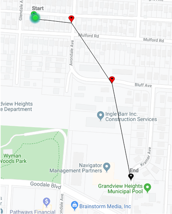
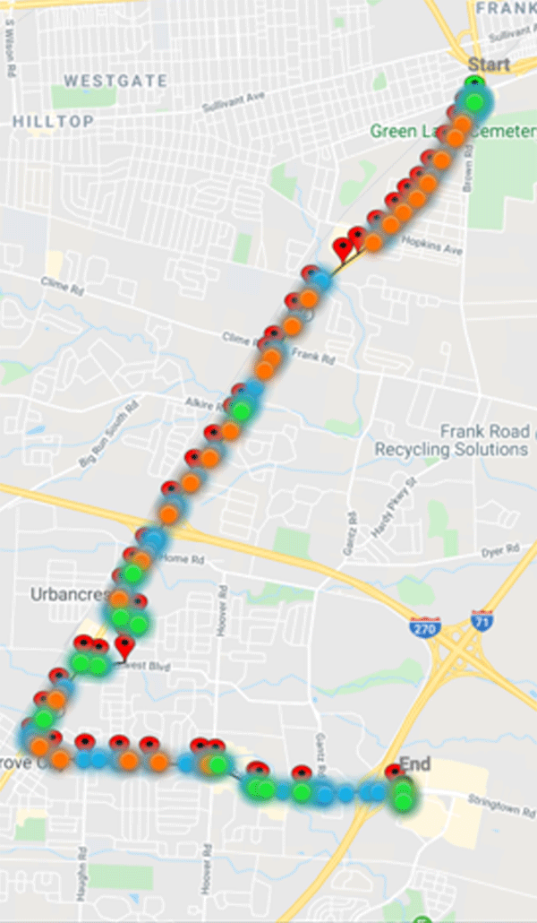
For preliminary data analysis, the data for four routes and two different participants have been analyzed in a case study fashion to delve into the different types of routes and data presented through the WayFinder Tracker. The four case studies represent a route that was either Cancelled, Completed, or In Progress. The trips' end statuses are determined by the WayFinder app and reported to the WayFinder tracker website. The data points of interest for these four routes can be seen in Table 1.
| Case Study | 1 | 2 | 3 | 4 |
| Participant | A | A | B | B |
| Trip End Status | Cancelled | Completed | In Progress | Completed |
| Elapsed Time (HH:MM:SS) | 01:32:10 | 00:45:42 | 4656:56:00 | 00: 30:19 |
| Waypoints (red) | 40 | 38 | 2 | 38 |
| Waypoints Hit (blue) | 36 | 38 | 1 | 36 |
| Waypoints No Response (orange) | 36 | 37 | 0 | 25 |
| Waypoints Responded (green) | 0 | 1 | 0 | 13 |
| Destination Hit? | Yes | Yes | Yes | Yes |
| Done Pressed? | No | Yes | No | Yes |
| Trip Paused? | Once | Never | Once | Never |
| Trip Type | Bus | Bus | Car | Bus |
| Battery Level Decrease | 10% | 12% | 1%* | 8% |
| Percent of Trip On Route | 100% | 100% | 100% | 100% |
| *Battery level decrease for this case study is based on time until the app stopped recording data and does not reflect battery level decrease for a completed route of the same elapsed time. | ||||
In addition to quantitative data provided by the app, maps of the routes are available on the WayFinder tracker website highlighting the individual waypoints for the trip (Figures 1-4). The blue circles symbolize Waypoint Hit, the orange circles symbolize Waypoint No Response, and the green circles symbolize Waypoint responded. Therefore, each waypoint should have at least one blue circle (Hit) and one orange (No Response) or green (Responded) circle.
DISCUSSION
In order to address the transportation barriers for individuals with cognitive disabilities, Livingston-Lee et al. (2014) describes recommended features for a personal navigation app [3]. The features include voice instructions, customized reminders, pictures, and system alerts. The functionality of these features is based on the individual waypoints. Therefore, we are able to use these waypoints and app features to generate metrics that describe an individual's route and the individual's interaction with the app.
The four cases studies represent four different scenarios that characterize typical routes. The individual's route characteristics and individual's interaction with the app are described based on the Wayfinder app metrics. The number of Waypoints describes the route custom-created for the traveler by their caregiver or community specialist and the number of Waypoints Hit describes the number of notifications the traveler was given while taking their trip. The number of Waypoints Hit (blue), and the combination of Waypoints Responded (green) plus Waypoints No Response (orange), should equal the Waypoints (red) created by the travel partner. Because there is a difference in the number of Waypoints and the number of Waypoints Hit (Cases 1, 3, & 4), there may be some inconsistencies in the way the app is recognizing the routes. The inconsistency may be due to the app, the app settings, the phone or a combination of the all three. Also, it may be due to bus detours or route changes. Regardless of the accuracy of the phone and app to detect every waypoint, or the status of the bus route, a travel partner who is using the tracker website (Figures 1-4) would be able to confirm that the traveler is on the route, and that the phone/app combination is functioning correctly.
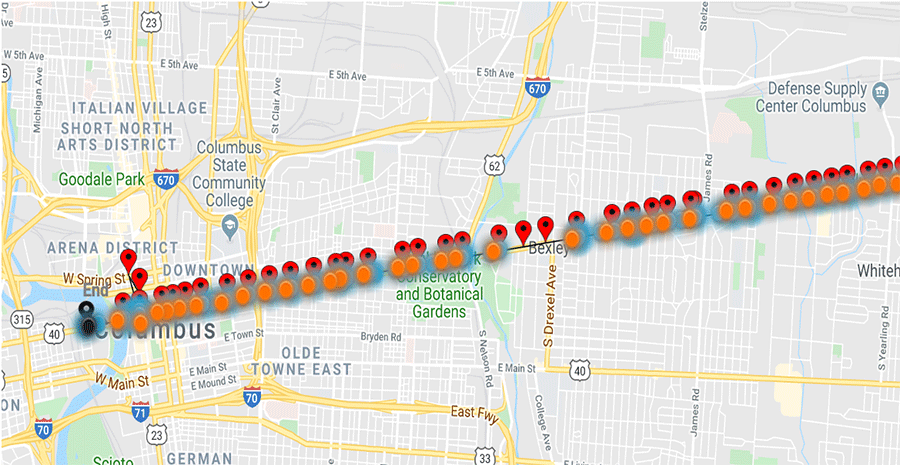
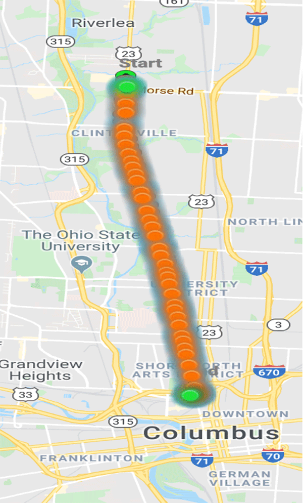
In the first case study, all the waypoints that were hit were not responded to as seen in Table 1, but the route map shows that not all the waypoints along the whole route were hit. As seen with the data in Table 1, 36 out of 40 waypoints were hit and all 36 were registered as Waypoint No Response. One can infer that the participant actually went on the route, but did not interact with the app while on the trip. Similarly, in the second case study, 38 waypoints were hit, but only one waypoint was responded to and the rest were registered as Waypoint No Response and the done button had not been pressed. This allows us to assume that, again, the participant went on the route but had limited interaction with the app while traveling. The participant from the first two case studies is part of a group who all go on routes together weekly. This may explain the lack of interaction with the app because the participant could be watching another group member interact or feel comfortable with the route because of the high frequency of trips. Unlike the first two case studies, the participant in the third case study most likely did not actually take the route because the map does not show any colored circles representing a Waypoint Hit and Table 1 only has data for one Waypoint Hit and no data for a Waypoint Response or Waypoint No Response. A possible explanation for this is that the phone battery was low when the route began, so the phone may have died in the middle of the trip. Another possible explanation for this data in case study 3 could be a lack of GPS signal in the area where the trip was taken. In the fourth case study, 36 out of 38 waypoints were hit, 13 were responded to, and the done button was pressed, allowing research personnel to assume that the trip was actually taken and that the traveler had some interaction with the app while on the trip. In case studies 1, 3, and 4, there are some waypoints that are not hit. Possible explanations for this could be loss of cellular service on the device, loss of GPS service in the area where the waypoint is located, or difference in bus routes. Differences in bus routes occur because of construction, special events, or time of day when the trip is taken.
FUTURE IMPLEMENTATION AND CONCLUSION
Based on the case studies and previous research, research personnel were able to demonstrate the feasibility for describing personal navigation for individuals with cognitive disabilities. For future data analysis, more case studies should be evaluated to search for trends in the data. This could potentially provide an explanation for errors with the WayFinder system or the COTA bus system in general. Research personnel in the MAPCD study should also go on routes with participants in order to evaluate their proficiency with the app and COTA bus system to evaluate if lack of user interaction with the WayFinder app is due to an increased confidence or dissatisfaction with the app. Once the reason for limited interaction is identified, research personnel can work with caregivers or community specialists to customize the routes to fit the needs of the individuals and can report back to the city of Columbus for future research opportunities.
REFERENCES
Journal articles:
- Lindsay, S., & Lamptey, D.-L. (2018). Pedestrian navigation and public transit training interventions for youth with disabilities: a systematic review. Disability and Rehabilitation, 1-15. https://doi.org/10.1080/09638288.2018.1471165
- Davies, D. K., Stock, S. E., Holloway, S., & Wehmeyer, M. L. (2010). Evaluating a GPS-based transportation device to support independent bus travel by people with intellectual disability. Intellectual and Developmental Disabilities, 48(6), 454–463. https://doi.org/10.1352/1934-9556-48.6.454
- Livingstone-Lee, S. A., Skelton, R. W., & Livingston, N. (2014). Transit Apps for People With Brain Injury and Other Cognitive Disabilities: The State of the Art. Assistive Technology, 26(4), 209–218. https://doi.org/10.1080/10400435.2014.930076
![]() 1
1 ![]() WayFinder 3 application created by AbleLink Technologies, Colorado Springs, Colorado
WayFinder 3 application created by AbleLink Technologies, Colorado Springs, Colorado