Olejniczak, E.1, Noyce1, Islam, M. F.2, Banerjee, R. 3, Raychoudhury, V.3, Gani, M.O. 2, and Smith, R. O.1
1 Rehabilitation Sciences & Technology, University of Wisconsin, Milwaukee, 2 Information Systems, University of Maryland, Baltimore County, 3 Computer Science and Software Engineering, Miami University
INTRODUCTION
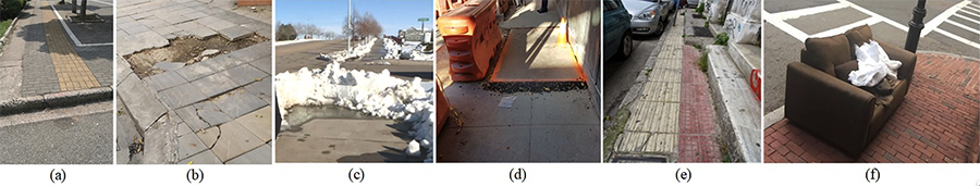
People with mobility impairments experience innumerable challenges while navigating the built and natural environment on a daily basis. Among people with mobility impairments, many are wheelchair users. While moving through unfamiliar surroundings, they encounter various path-related barriers which can hinder their travel plan and discourage them from future endeavors. Our research team has identified common path barriers by interviewing multiple wheelchair users and by moving through the built environment and we present those in Fig. 1. The ability to identify the most accessible route from source to destination is crucial for wheelchair users. We have previously proposed MyPath as a personalized accessible routing system for wheelchair users [1]. We have recently completed the data collection operation of MyPath system and initiated alpha testing with the research team members and Participatory Action Research (PAR) group members. In this paper we describe the data collection functionalities of MyPath and discuss the feedback and suggestions of our PAR members. We also describe our future directions for using the collected data and our plan for field testing.
RELATED WORKS
In this section, we summarized the research outcomes of a large number of scholarly articles related to the domain of smart navigation and accessible routing. We have classified them under two major categories - 1) Crowdsourced Data Collection, and 2) Mobility Assistants.
Crowdsourced Data Collection
The emergence of hand-held mobile devices such as smartphones has enabled the use of crowd-sourcing for data collection in navigation systems. RouteCheckr [13] is a routing system developed using collaborative data for creating customized routing options. Similarly, mPASS [9] used crowdsourced as well as sensor data to generate personalized routes. eNav [3] employs a crowdsourced database - OpenStreetMap [9] (OSM) for creating accessible routing paths.
Mobility Assistants
MAGUS [8] was one of the first mobility assistants that developed a GIS model with an interactive UI to assist users in navigating easily in Northampton, UK. MAGUS used network analysis tools for routing purposes. Machine learning was first applied by [6] to create accessible routes for users with visual, hearing, and limb impairments in Georgenthal, Germany. A more personalized system, U-Access [12] was tested at the University of Utah for customized accessible routing based on the user's physical ability. Many new applications [2, 4, 11] use in-built smartphone accelerometers, gyroscopes, and location information for accessible routing.
MYPATH DATA COLLECTION METHODOLOGY
To address the challenges encountered by the existing accessible routing and navigation systems, we propose the novel MyPath system which aims to generate end-to-end accessible routes for wheelchair users depending on surface-induced vibration patterns. To facilitate this research, we plan to collect surface vibration data from multiple participants in a crowdsourced manner using smartphone-embedded motion sensors (like accelerometers and gyroscopes) along with their GPS traces. The MyPath App will be installed on a smartphone (iOS or Android). This smartphone is then tightly attached to the wheelchair. It might even be carried by users in their pockets or backpacks while ensuring minimum external vibration apart from that caused by the surface. The MyPath app has 'start' and 'stop' buttons to initiate and terminate data collection by users while in motion. If allowed by the user, vibration and location data are captured by the App and sent to the server for storage and processing.
PARTICIPATORY ACTION RESEARCH (PAR) METHODOLOGY
Participatory Action Research (PAR) is a collaborative approach to collecting information about an issue utilizing a group of people who are involved in or concerned about the research being addressed [7]. PAR challenges mainstream traditional research and has a strong focus towards social change. PAR members 'participate' in a discussion, identify the challenges they face, and provide solutions. This is done through a series of repetitive steps involving 'Action' and 'Reflection'.
PAR members were recruited to form a diverse team that offers unique perspectives and personal experiences regarding wheelchair routing and path accessibility. We emphasized the experiences of individuals with different developmental, vision, and ambulatory disabilities. The inclusion of members who work or hold a stake in accessibility issues was also prioritized, this included university campus planners, city accessibility coordinators, and various disability organizations. Once the recruitment goals were set, recruitment was initiated via email and phone. A total of 12 PAR members were identified, including wheelchair users, individuals with varying visual impairments, and experts in accessibility and community participation. These experts work in areas of campus accessibility, senior living, disability studies, and in community disability centers. Once selected, we began to collect useful data and insights into the issues that could be addressed using the MyPath app. The process began with the MyPath internal team presenting our initial set of hypotheses and incorporating them into the discussion of development. The PAR teams' personal experiences, perspectives, and feedback have been the core data shaping the development of the MyPath app. This contributed to the unique goal of the app to provide a community targeting app based on what the community wants.
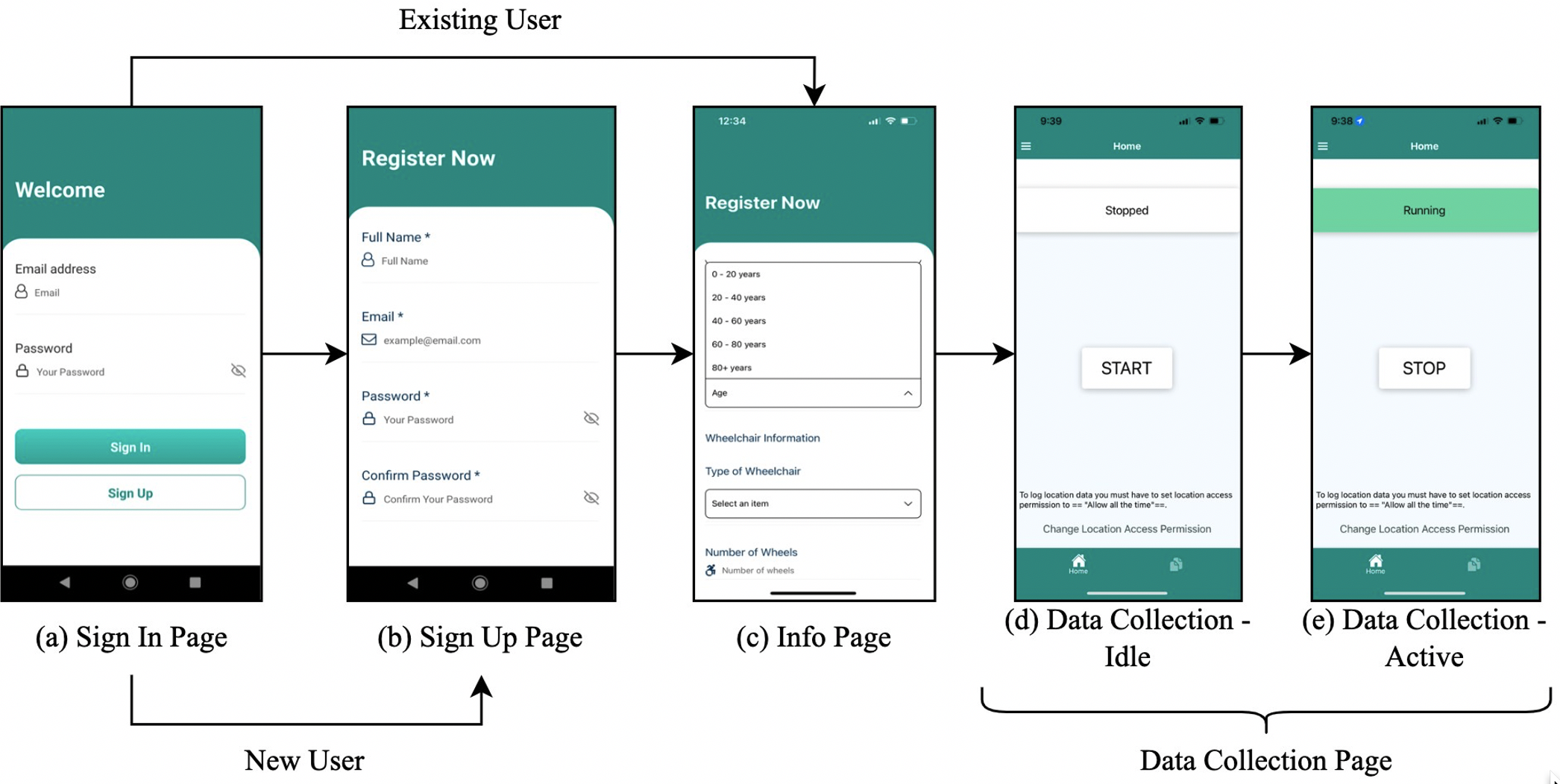
Figure 2 shows the app user interface and data collection process we have asked the PAR members to evaluate. Figure 2(a) shows the welcome page which appears as the user opens the app. As directed, a new user will move to the sign-up page shown in Figure 2(b). Here the user will create a custom profile that provides information to the app which then produces custom results based on individual needs. Examples of these questions are seen in Figure 2(c) and can include "Age", 'Type of Wheelchair", and 'Number of Wheels". Figure 2(d, e) show the data collection pages, first Figure 2(d) when the app is not running followed by Figure 2(e) showing when the app is actively collecting data. The MyPath team developed a testing protocol to optimize the app before data collection began. This protocol was divided into categories: captured trip data, app features, and generic testing items. The capture trip data evaluated factors including user data, path mapping, and issue reporting. In the app features the categories are app functionality, app accessibility and usability, and user feedback mechanisms. In the generic testing items, there are categories of individual functionality, modular testing, and integrated testing.
PAR FEEDBACK
Once our PAR team was set, quarterly meetings were scheduled. Four, 2-hour PAR meetings have been held to discuss the progression of the MyPath project and give feedback on all elements of development. Most recently, the focus of the MyPath PAR meeting was to give feedback on data collection and test the app. PAR members downloaded the MyPath app, and began reporting initial feedback on the design of the app, terminology used, design and testing process, and conceptual aspects of the app. There was no technical discussion of the app. There are two types of feedback the MyPath team used to guide data collection. Type one is real-time feedback, this was collected during the fourth PAR meeting. The meeting was focused solely on data collection and produced many important comments and suggestions. Feedback was collected on the installation of the app, the signup process, the data collection process, and the overall UI/UX. The second type of feedback is the continuously collected feedback as the PAR team performs data collection and app testing. The MyPath internal and PAR team use an excel sheet to accumulate data and app needs. This is an ongoing process and app alterations are made as the information comes in.
Guided by the testing protocol, PAR members downloaded the MyPath app and provided real-time feedback during the meeting. Overall, we received dozens of valuable insights from the PAR members which primarily fell into three distinct categories. The first category is terminology and relevance of the user data solicited by the app. For example, the app asks for a user's weight; however, it was noted that many wheelchair users do not know their weight outside of their wheelchair. Similarly, height is asked in inches, and it was noted that a user may not easily be able to calculate their height in inches. The second category is aspects which may alter the data collection. PAR members suggested adding an ability to report circumstantial modifiers which may affect the data collected. These modifiers include the presence of a backpack which may add weight and alter the balance of the chair and weather-related conditions such as rain or ice. It was also suggested adding options to indicate if the wheelchair user is ambulatory, if there are add-ons to the wheelchair, and if someone is pushing the wheelchair. PAR members discussed reporting how temporary a barrier is and how significant it is for path navigation. The third feedback category is how the data collectors will report feedback within the app. PAR members discussed different ways feedback can be reported, what and when feedback should be requested, and making feedback optional, as mandatory feedback can be burdensome. This PAR feedback has been inputted into the MyPath team's development system for immediate inclusion in the app or for ongoing discussion of these factors.
FUTURE PLAN FOR FIELD TESTING AND INTEGRATION OF FIELD TESTING RESULTS
Once the alpha testing of the data collection app is completed with the active involvement of the research team members and the PAR group members, we plan to recruit participants for the actual field testing. We have a number of partner organizations who have committed to providing help reaching out to interested participants. Our community partners are - (1) the Miami University Office of Student Disability Services (SDS), (2) the University of Maryland Baltimore County (UMBC) Office of SDS, (3) the University of Wisconsin Milwaukee (UWM) Office of SDS, (4) Oxford (OH) City Council, (5) Milwaukee (WI) Milwaukee County Aging and Disability Services, (6) Baltimore (MD) County Department of Aging, (7) Kent County (MI) city council, (8) Butler County (OH) Board of Developmental Disabilities, (9) Oxford (OH) Visitor's Bureau, (j) Oxford (OH) Chamber of Commerce, (10) Mary Free Bed Sports Rehabilitation hospital and YMCA (MI), (11) Scripps Gerontology Center, Miami University, (12) Hamilton County (OH) Developmental Disabilities Services, (13) National Seating and Mobility Inc. (14) NuMotion Inc. Apart from these large organizations we also have several individual stakeholders who serve as disability advocates and can help us to reach out to many interested participants. We have set a target of recruiting 120 wheelchair users from three different rural and urban areas - Oxford (OH), Milwaukee (WI), and Baltimore (MD). We will reach out to potential participants through email, website, recruitment flyers, and other viable means.
The sensor data and GPS traces collected from alpha and field testing will be used to build a model for automated surface classification based on vibration patterns. The surface information is then used to generate end-to-end accessible routes for wheelchair users customized to their personal requirements and wheelchair capabilities. One of the major contributions of our work will be a robust machine-learning algorithm for surface classification. The ML model will be trained with vibrational data collected from different surface types. The ML algorithm factors in various dynamics such as height from the ground, orientation, and position of the smartphone. Automated surface classification outcomes are then updated in OpenStreetMap for use by the route generation module. An algorithm for accessible routing fetches surface and slope information from the OSM and outputs the most accessible routes for a particular user. Routing in MyPath is being implemented using the open-source GraphHopper system [5] and can be visualized either through a web or a smartphone interface.
CONCLUSION
Individuals with mobility impairments face a wide range of barriers during their day-to-day ambulation which challenge their independence. To provide efficient travel experiences to mobility-challenged individuals, especially for wheelchair users, different path characteristics are considered. The MyPath system was developed to provide an end-to-end accessible routing solution for these individuals. Through the feedback from the PAR members, we can identify the usability, accessibility, and acceptability of this system. Soliciting feedback from wheelchair users, community members, and disability experts creates an informed app which will provide a more accessible and curated experience for its users. This feedback, in addition to the actual data collected and the machine learning algorithm of the app will lead to the most useful, personalized, and accessible app for wheelchair users.
REFERENCES
- S. Saha, L. Selingo, E. Olejniczak, H. Noyce, V. Raychoudhury, R. O. Smith, and M. O. Gani. MyPath: Accessible Routing for Wheelchair Users. Rehabilitation Engineering and Assistive Technology Society of North America (RESNA), 2022.
- A. Bujari, B. Licar, and C. E. Palazzi. Movement pattern recognition through smartphone's accelerometer. In 2012 IEEE Consumer Communications and Networking Conference (CCNC), pages 502–506. IEEE, 2012.
- D. Dzafic, P. Schoonbrood, D. Franke, and S. Kowalewski. ENav: A suitable navigation system for the disabled, pages 133–150. Springer, 2017.
- R. Harle. A survey of indoor inertial positioning systems for pedestrians. IEEE Communications Surveys & Tutorials, 15(3):1281–1293, 2013.
- P. Karich and S. Schroder. Graphhopper directions api with route optimization (2017), 2009.
- D. Karimanzira, P. Otto, and J. Wernstedt. Application of machine learning methods to route planning and navigation for disabled people. In Proceedings of the 25th IASTED International Conference on Modeling, Indentification, and Control, MIC'06, page 366–371, USA, 2006. ACTA Press.
- S. Kindon, R. Pain, and M. Kesby. Participatory action research approaches and methods. Connecting people, participation and place. Abingdon: Routledge, 260, 2007.
- H. Matthews, L. Beale, P. Picton, and D. Briggs. Modelling access with GIS in urban systems (magus): capturing the experiences of wheelchair users. Area, 35(1):34–45, 2003.
- OpenStreetMap. Planet OSM Files, 2022.
- C. Prandi, P. Salomoni, and S. Mirri. mpass: integrating people sensing and crowdsourcing to map urban accessibility. In Proceedings of the IEEE international conference on consumer communications and networking conference, pages 10–13, 2014.
- V. Renaudin and C. Combettes. Magnetic, acceleration fields and gyroscope quaternion (magyq)-based attitude estimation with smartphone sensors for indoor pedestrian navigation. Sensors, 14(12):22864– 22890, 2014.
- A. D. Sobek and H. J. Miller. U-access: a web-based system for routing pedestrians of differing abilities. Journal of geographical systems, 8(3):269–287, 2006.
- T. Volkel and G. Weber. Routecheckr: personalized multicriteria routing for mobility impaired pedestrians. In Proceedings of the 10th international ACM SIGACCESS conference on Computers and accessibility, pages 185–192. ACM, 2008.
ACKNOWLEDGEMENT
This work was developed in part under a grant from the National Institute on Disability, Independent Living, and Rehabilitation Research (NIDILRR grant number 90IFDV0024). NIDILRR is a Center within the Administration for Community Living (ACL), Department of Health and Human Services (HHS). The content of this work does not necessarily represent the policy of NIDILRR, ACL, HHS, and you should not assume endorsement by the Federal Government.